
Serving Southern Jefferson County in the Great State of Montana
Serving Southern Jefferson County in the Great State of Montana
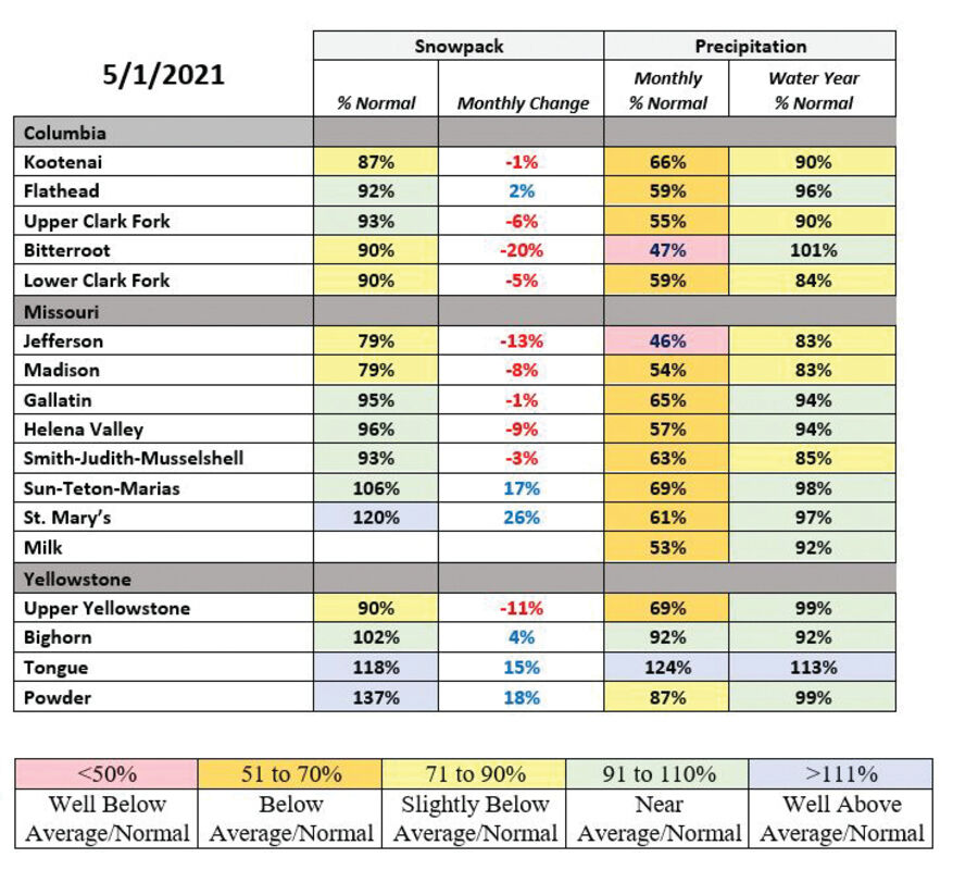
Following on the heels of a March which yielded well below average mountain and valley precipitation, April delivered the same pattern of dryness with monthly temperatures once again vacillating from well above average to well below average during the month. "April yielded a little bit of everything in the temperature department. The month began with record warmth at mountain locations, which transitioned the low elevation snowpack to melt by the end of the first week," said Lucas Zukiewicz, water supply specialist for the Natural Resources Conservation Service (NRCS) in Montana. Although temperatures moderated during the second week of the month, prolonging the snowpack at mid and high elevations, low elevations continued their release of snow water during the month.
As of May 1, nineteen low-elevation SNOTEL sites across Montana have melted out, which is slightly more measurement locations than normal for this date. "The low-, and even mid-elevation, snowpack melt is most notable in southwest Montana where some measurement locations have melted out two to three weeks ahead of schedule," said Zukiewicz.
The mid- and high-elevation snowpack in the state began the transition to melt during the last week of the April, when temperatures once again rose to above seasonal normal. "The temperatures at the end of April and beginning of May were the tipping point for the snowpack at the mid and high elevations," said Zukiewicz. "As of now, all elevations are melting at a pretty good clip. Now that the bulk of mountain snowpack reservoir is pouring out of mountain locations, rivers and streams will begin their big seasonal increases in flows."
This year, both the peaks in Montana's rivers and the overall volume of runoff are likely to be impacted by the weather experienced during March and April. "Since the low elevation snowpack has melted out across the state, and the mid and high elevations didn't add the expected amount of water to the snowpack during April, the resulting seasonal volumes for the remainder of the runoff season are forecasted to be below what was expected on April 1," said Zukiewicz.
Streamflow forecasts issued by NRCS on May 1 indicate that while March and April yielded below normal precipitation, near to slightly below average streamflows are still possible for many of Montana's rivers. "October and February saved snowmelt driven runoff in these basins. Without those two months of above normal snowfall, we would be facing the prospect of below normal runoff across the state," said Zukiewicz.
For one area of the state, which didn't receive the boost to mountain snowpack in the year and was already experiencing impacts from the lack of precipitation spanning back to last summer, the lack of March and April precipitation has made it more likely that streamflows will be below average to well below average this summer. "Southwest Montana has been persistently dry since last summer and flows in the tributaries to the Jefferson River basin look to be well below normal for overall volumes this spring and summer. Water users in this area, and downstream on the Missouri, should be aware of this possibility, especially if May and June precipitation fails to materialize," said Zukiewicz.
The final Water Supply Outlook Report of 2021 will be posted during the first week of June and will summarize May weather patterns, and how that might impact the remainder of runoff this year. A full report of conditions for May 1 can be found in the monthly Water Supply Outlook Report available on the Montana Snow Survey website. In addition, real-time snow survey data can be found at https://www.nrcs.usda.gov/wps/portal/nrcs/mt/snow/


Reader Comments(0)