Serving Southern Jefferson County in the Great State of Montana

Streamflow forecast improves

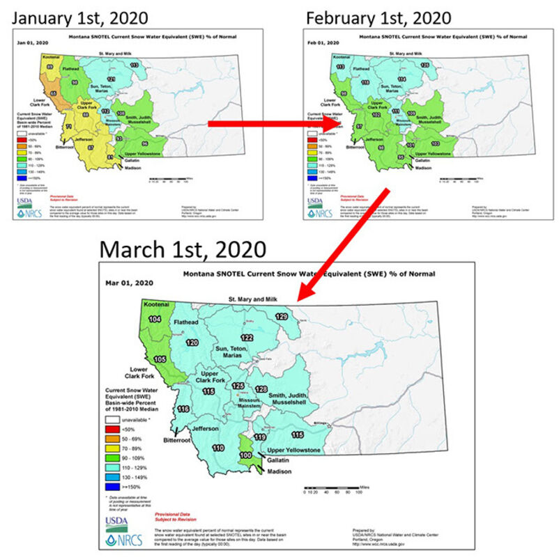
Following on the heels of January's abundant snowfall, February also delivered above normal to record-setting snowfall in mountain ranges supplying water to regional rivers and streams. New records were set for February snowfall at seven mountain SNOTEL (SNOwpack TELemetry) sites in southern and central Montana that were favored by the unstable north-northwest flow coming from Canada during the first three weeks of the month.

The recovery in snowpack was well timed. "January and February snowfall took the dismal snowpack totals reported on January 1 along the Montana/Idaho border and improved snowpack to near to above normal on March 1," said Lucas Zukiewicz, USDA Natural Resources Conservation Service water supply specialist for Montana. "This is great news for water users as we approach spring and summer." Snowpack totals in all river basins across Montana are now near to above normal for March 1.

At this point in the winter, around 75 to 85 percent of the seasonal peak snowpack has typically accumulated at mountain locations. This data gives forecasters clearer insight into what the snowmelt may yield in seasonal water supply during spring and summer. "Streamflow prospects for spring and summer look to be near to slightly above average at this time due to the healthy snowpack totals we have in the mountains," Zukiewicz said. However, he warns that "future snowfall, spring precipitation and temperatures during the next three months will play a critical role in both the timing and volumes we experience during runoff this year."

As the transition into spring continues, weather patterns across Montana will change. Mountains west of the Divide typically experience lower monthly snow totals through spring. However, spring months can be significant to river basins east of the Divide. "Even though spring starts on March 19, there is still typically a lot of winter left to come in the mountains, and the juicy months are on the horizon for some of our east of the Divide river basins. These months can make or break our spring and summer streamflows," said Zukiewicz.

Long-range forecasts issued by NOAA's Climate Prediction Center for the next two weeks (March 3-17) indicate better than normal chances of above average temperatures across the state and near to below normal precipitation. "While we've got more water than we typically have stored in the snowpack on March 1, I've learned from experience it's never wise to assume we will be in the same shape come May 1," said Zukiewicz.

Monthly Water Supply Outlook Reports can be found at the website below after the fifth business day of the month: https://www.nrcs.usda.gov/wps/portal/nrcs/mt/snow/


Reader Comments(0)


Rendered 03/28/2024 11:36